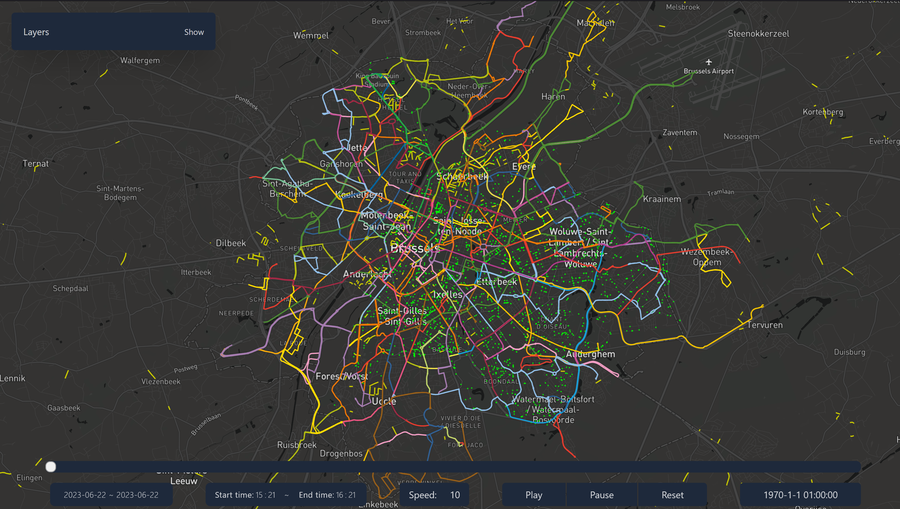
The Mobility Data Platform For Brussels
Unlock diverse, quality mobility data in Brussels for insights, planning, and innovation.
Register now Discover our API
All the data you need in one place
Access diverse, quality-assured mobility data in Brussels for insights, planning, and innovation. Explore real-time and historical data from various sources like public transport, micro-mobility, railway, traffic, and air-quality feeds. Power your data-driven solutions for optimized urban mobility.
Real-time
Access to real-time geospatial location feeds of various mobility sources, including public transport vehicles, micro-mobility vehicles, railway trains, traffic, and air-quality feeds.
Enriched data
Processed data is enriched and integrated, allowing users to build applications using high-quality and enhanced data.
Centralized access
Acts as a centralized access point for all mobility-related information in Brussels, eliminating the need to search through multiple sources.
Historical Data Archives
Provides access to large amounts of historical mobility data, enabling research work on batch mobility data management and analytics.
Data Cleansing and Fusion
Provides efficient pipelines for data cleansing, enhancement, and fusion, ensuring high-quality and usable data for analysis and decision-making.
Open Data Collaboration
Encourages applied research efforts and collaboration with the research community to refine and improve the dataset, maximizing its value for various stakeholders.
An open data ecosystem to drive innovation and research
The Mobility Twin for Brussels is a unique open data ecosystem that allows you to access and use mobility data from the Brussels-Capital Region. It is a unique opportunity to develop innovative solutions for the mobility of tomorrow.
SNCB
SNCB is the national railway company of Belgium. It is an autonomous government company.
It is responsible for the operation of the national railway system. It provides a GTFS
and GTFS-RT feed. The MobilityTwin.Brussels platform enriches these by providing estimated
positions of the trains based on the GTFS-RT feed. It also provides the vehicle_schedule
endpoint which provides the schedule of the trains per stop for a given period of time.
Source
INFRABEL
Infrabel is the company which manages the railway infrastructure in Belgium. It provides
a detailed map of the railway network in Belgium. They also provide a daily report of the lateness of
the trains.
Source
STIB
STIB is the main public transport operator in Brussels. It has its own open data platform
which provides different data sets. The GTFS feed is used to provide the schedule of the
vehicles. Contrary to the SNCB and other operators, the STIB does not provide a GTFS-RT feed.
It provides different proprietary APIs to get the real-time data. The MobilityTwin.Brussels
platform provides a vehicle_position endpoint which provides the estimated positions of
the vehicles based on the GTFS feed and the proprietary APIs. It also provides the vehicle_schedule
endpoint which provides the schedule of the vehicles per stop for a given period of time.
Source
TEC
The TEC is the main public transport operator in Wallonia with a fraction of its network in Brussels. It publishes a GTFS feed which is used to provide the schedule of the vehicles and a GTFS-RT feed which is used to provide real-time data.
ExploreDE LIJN
De Lijn is the main public transport operator in Flanders with a fraction of its network
in Brussels. It publishes a GTFS feed which is used to provide the schedule of the vehicles and a
GTFS-RT feed which is used to provide real-time data.
Source
MICROMOBILITY
Micromobility is a new form of mobility which is growing in Brussels. It includes bikes, scooters, etc. It is becoming more and more important in the mobility landscape of Brussels which is transitioning towards a more sustainable mobility. The MobilityTwin.Brussels platform provides separate endpoints for each operator. The data is provided in the GeoJSON format.
ExploreTRAFFIC
The traffic component provides some information about the traffic in Brussels. It uses Telraam data to provide the number of vehicles per hour per day for certain segments of the Brussels road network. An other endpoint provides the count of vehicles registered by the cameras present in the tunnels of Brussels.
ExploreENVIRONMENT
The environment component provides some information about the environment in Brussels. It uses OpenWeather data to provide the weather for Brussels. An other endpoint provides the air quality data for Brussels (provided by Irceline).
Explore
An open data ecosystem to drive innovation and research
As an open data platform, the Mobility Twin for Brussels is a collaborative project. You are always welcome to contribute to the platform by adding new data sources, improving the data quality, or enriching the data by creating new data products.
ContributeCitation information
If you use the platform or the data provided by the platform in one of your projects, please cite the paper below:
@article{merten_sakr_mobilitytwin_2023,
title = {Brussels Mobility Twin (Data and Resources Paper)},
author = {Gaspard Merten and Mahmoud Sakr},
booktitle = {The 31st ACM International Conference on Advances in Geographic
Information Systems (SIGSPATIAL '23)},
year = {2023},
address = {Hamburg, Germany},
publisher = {ACM},
doi = {10.1145/3589132.3625634}
}